Storm Eowyn: Rail, road, sea and air travel disrupted as Met Office weather warnings come into effect


Storm Eowyn (pronounced "ay-oh-win") is forecast to bring strong winds to much of the UK[1] on Friday and into Saturday. The latest bout of severe winter weather is already causing travel disruption, with rail firms cancelling some trains on Friday - one is warning passengers not to travel north of York. Simon Calder, Travel Correspondent of The Independent, has been surveying the likely damage to travel plans.
Let's start with the warnings from the Met Office.
What are we expecting?
-
Thursday: from 7am to 6pm, a yellow warning[2] for "strong and gusty winds" across almost the entire coast of Wales - except for the stretch from Colwyn Bay to Chester - and the entire coast of southern England from the Bristol Channel around to Ramsgate. "Some coastal routes, sea fronts and coastal communities will be affected by spray and/or large waves," says the Met Office.
-
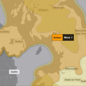
Friday: the whole of the UK has Met Office warnings for wind, in Scotland snow, and in southwest England and South Wales, rain. The worst weather is the subject of an amber warning that runs from 6am to 9pm and covers North Wales, northern England from Manchester and Leeds, as well as the Peak District, southern Scotland and all of Northern Ireland. The Met Office says: "Road, rail, air and ferry services are likely to be affected, with longer journey times and cancellations possible.
Some roads and bridges will close."
-
Saturday: all of Scotland apart from the Borders is subject to a yellow warning for wind until 3pm.
Looking at the roads, what are the motoring organisations saying?
RAC Breakdown spokesperson Alice Simpson said: "Strong winds mean there's a higher likelihood of fallen branches and trees on rural routes between motorways and A-roads, which can obstruct journeys and puncture tyres if not carefully avoided. Drivers also need to be well aware of the buffeting effect of sudden gusts, especially along coastlines and exposed areas where the worst weather is expected. High-sided vehicles are most at risk of being blown off course, but cars can also be affected as they pass lorries on the motorway and are then hit by the wind on the other side.
It's best to keep speeds low and have a firm grip on the wheel to avoid being caught off-guard, especially in areas where heavy rain will affect visibility." ADVERTISEMENT The AA is advising drivers to check forecasts before venturing out and to adjust their speed to suit the conditions. "Keep an eye out for gaps between trees, buildings or bridges over a river or railway - these are some of the places you are more likely to be exposed to side winds," the organisation says. "In the most affected areas drivers are asked to consider if their journey is necessary."
Rail firms have already started cancelling trains?
Yes - the entire intercity route between Newcastle and Edinburgh will be closed on Friday 24 January "for safety reasons".
No rail replacement buses will be provided. LNER[3] says you should not travel north of York. Passengers are told they can use tickets for Friday on Thursday or up to Monday 27 January, but at the weekend London-Peterborough is closed for engineering work. TransPennine Express says most routes will be disrupted and is telling people not to use its Anglo-Scottish trains from Liverpool, Manchester and York.
Friday tickets are valid from Thursday to Monday. "We are expecting gusts of up to 90mph in Cumbria and Lancashire on Friday due to Storm Eowyn," warns Network Rail Lancashire & Cumbria. "We expect disruption." Typically a speed limit of 50mph is imposed to contend with the risk of of debris, from trees to trampolines, being blown onto the track. Even if the lines are clear, running slower trains inevitably leads to delays and cancellations.
ADVERTISEMENT Avanti West Coast[4] says: "We're advising customers not to travel north of Preston or on our North Wales route on Friday 24 January due to the expected disruption by Storm Eowyn."
What about the ferries?
The Thursday evening Dublin-Holyhead sailing on Irish Ferries[5] has been cancelled, and other ships on the route are departing earlier than normal. Other Irish Sea ferries are very likely to be disrupted.
Many Caledonian MacBrayne ferries for Friday have already been cancelled, and services later on Thursday may be axed.
How many flights will be affected?
Impossible to to say at this stage, but Edinburgh, Glasgow and Newcastle airports are squarely in the amber warning area and Manchester and Leeds Bradford just outside it.
Scotland's airline, Loganair, is allowing anyone booked on Friday to switch to another day up to a week ahead to avoid the risk of disruption.
The same applies for all Scottish flights.
References
- ^ bring strong winds to much of the UK (uk.news.yahoo.com)
- ^ yellow warning (www.independent.co.uk)
- ^ LNER (www.independent.co.uk)
- ^ Avanti West Coast (www.independent.co.uk)
- ^ Irish Ferries (www.independent.co.uk)