UK to experience small reprieve from rain before fresh wet weather rolls in
The UK is set to experience a small reprieve from heavy rainfall before fresh wet weather rolls in.
The Met Office had issued yellow rain alerts lasting until Sunday evening for all of England and Wales but the warning was updated to be in force until noon, covering the South East of England.
The forecasting body predicted a drier Sunday but said the “odd spot of rain” will still fall in parts of Western Scotland, North West England, Wales and South West England.
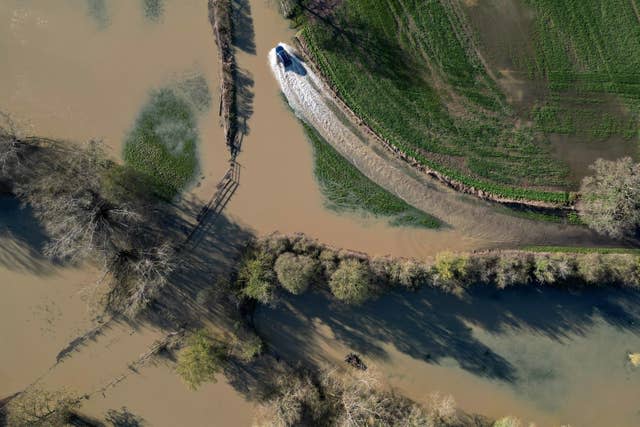
More than 60 flood warnings remain in place for England, meaning flooding is expected, with more than 10 flood alerts in force for Wales, meaning flooding is possible.
Between 3pm Saturday and 11am Sunday, there was 76mm of rainfall in White Barrow, Devon, 53mm in Priddy, Somerset, and 51mm in Eggardon Hill, Dorset.
Flooding in the South West was causing disruption to some train services on Sunday, including between Swindon and Bristol Parkway, affecting routes between London Paddington and Cardiff Central.
Routes between London and Penzance were also affected by flooding between Taunton and Westbury.
There are more than 50 flood warnings in place across England and 20 flood alerts in force for Wales (Jacob King/PA)
Met Office meteorologist Craig Snell said: “Quite a mild start to the day on Sunday, a wet start still down towards the South East and heavy rain from time to time.
“That will clear off towards France as we head towards lunchtime, and that will allow many eastern parts to actually have a fairly decent afternoon, a mixture of clouds and some sunny spells.
“Northern Ireland also seeing a relatively dry afternoon with some sunny spells but for Western Scotland, North West England, Wales, South West England, more in a way of cloud and that cloud will be thick enough in places to produce the odd spot of rain.”
He said temperatures in the north will reach between 11 and 13C, with temperatures in the south, particularly in the sunshine, reaching 15 or 16C.
The meteorologist warned the dry end to Sunday will be quickly followed by the “next area of rain”, with heavy rainfall in parts of North West England and Wales on Monday morning.
Story continues
But the wet weather is set to “weaken” as it moves eastwards so there will be “very little rain” arriving into parts of London and the South East.
“And in behind it plenty of sunshine developing probably one of the sunniest days of the week coming up,” he said.
“The odd shower is possible but I think most of us will be dry and then very later on we will start to see some thicker cloud and some outbreaks of rain just arriving into the far west of Northern Ireland and the far west of Scotland.”
He said “we all turn unsettled” as the week goes on with heavy rain “from time to time” and “increasing risk” of strong winds.