Storm Debi to batter parts of the UK this week
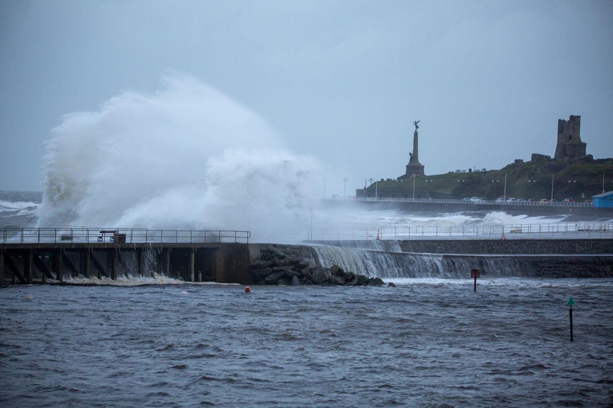 Storm Debi combined with high tide brings large crashing waves to Aberystwyth, Ceredigion, Wales, on Monday. (Alamy) (Ian Jones)
The UK is bracing for a week of wet and windy weather[1] as Storm Debi hits on Monday.
The Met Office[2] has issued amber weather warnings for wind in the north west of England and in Northern Ireland, meaning flying debris is likely and could lead to injuries or put people's lives at risk.
There will also be a risk of tiles being blown off the roofs of buildings as well as power cuts and transport disruption.
Power outages have been reported across the island of Ireland, with about 100,000 homes left without electricity after the storm made landfall overnight.
Much of the Republic of Ireland was covered by a red wind warning – the highest level of alert – on Monday morning.
#StormDebi[3] will bring disruptive winds to parts of the UK today
🔶 An Amber wind warning is already in effect in southeast Northern Ireland and a second Amber wind warning comes into force for northwest England from 10:00 this morning
⚠️ Take care and stay #WeatherAwarepic.twitter.com/WZ9QL8QwLQ[4][5]
— Met Office (@metoffice) November 13, 2023[6]
The Met Office amber warning in the North West is in place until 4pm on Monday, while the one in the south of Northern Ireland will last until midday.
In addition, there are yellow warnings for wind and rain in the North West, North East and parts of the Midlands, as well as in Northern Ireland, Scotland and Wales.
Heavy rain and severe gale-force winds are expected in affected areas on Monday. Storm Debi was named by Met Éireann – the Irish meteorological service – on Sunday morning.
The Met Office also warned that roads and bridges are likely to close, meaning longer journey times and public transport and other cancellations are possible, with road, rail, air and ferry services to be affected.
Watch: Storm Debi likely to bring dangerous winds as amber warnings issued
Those in coastal areas are warned to keep away from the waterfront, with large waves and beach material likely to be thrown onto coastal roads, sea fronts, and nearby properties.
“Storm Debi has developed rapidly overnight and will bring impacts across parts of the UK today," said Matthew Lehnert, chief meteorologist at the Met Office.
“Because of the particular risk of impacts to parts of County Armagh and County Down this morning and parts of north west England through much of the day we have issued two amber wind warnings.”
Recommended reading
The storm is forecast to sweep across Ireland before reaching northern England and parts of Wales on Monday, with the potential for 80mph gusts in some areas.
A yellow warning for wind, the lowest level of alert, will be in place until 6pm for areas including Bangor and St Davids in Wales and Manchester, Sheffield and Liverpool in England.
Aberdeenshire in Scotland will have a yellow warning for rain from 10am until 9pm.
In Scotland, the town of Brechin in Angus, which was battered by Storm Babet last month, is likely to see more heavy rain.

Jonathan Vautrey, meteorologist at the Met Office, said: “There will be some heavy rainfall, the potential for flying debris, the potential for disruption to travel and infrastructure in places.”
Jason Kelly, chief meteorologist at the Met Office, said: “The strongest winds are expected to affect parts of the Republic of Ireland early on Monday, possibly coinciding with the morning commute, before affecting parts of north Wales and northern England into the afternoon.
“Whilst the very strongest winds will have eased somewhat before reaching the UK, we are still expecting some significant impacts, and a wind warning has been issued.
As for the rest of the week across the UK, Tuesday will be a "breezy day with sunshine and showers", the Met Office said.
It forecast that rain in the north will ease on Wednesday although it will be breezy in other parts of the UK.
The wet weather will return to the country on Thursday, and it could be very windy in the south.
Yahoo News UK looks at what the weather will be like in your region this week according to the Met Office forecast.
North East
Monday and Tuesday
Heavy rain and strong winds or gales throughout Monday. Persistent and heavy rain accompanied by very strong winds or gales due to Storm Debi. Maximum temperature 10°C.
Bright with sunshine and occasionally heavy showers especially in the west on Tuesday. Winds also strengthening over hills for a time. Maximum temperature 9°C.
Wednesday to Friday
Further sunshine and showers on Wednesday. Dry start Thursday, becoming wet and windy later. Showers clearing early Friday, then bright with some sunshine. Temperatures close to average.
North West
Monday and Tuesday
Storm Debi bringing heavy rain and strong winds on Monday morning, with very strong and possibly damaging coastal gales developing into the afternoon. Heavy rain continuing in the north. Maximum temperature 12°C.
More showers expected through much of Tuesday, with a risk of some thundery outbreaks with hail. Breezy, especially along the coast. Maximum temperature 12°C.
Wednesday to Friday
Showery again on Wednesday though winds falling lighter. Rain returning on Thursday and perhaps windy for a time. Brighter weather with lighter winds and a few showers again on Friday.
South West
Monday and Tuesday
A heavy band of rain during the morning then scattered showers and sunny spells following in the afternoon. Strong winds throughout the day, with gales possible around coastal areas. Maximum temperature 15°C.
Tuesday will be a day of sunny spells and blustery showers, possibly heavy at times with the added risk of thunder. Winds remaining breezy.
Wednesday to Friday
Wednesday will bring lighter winds with sunshine and fewer showers. Overnight rain clearing east followed by showers on Thursday. Gales possible for a time. Brighter and less windy on Friday.

London and the South East
Monday and Tuesday
Persistent and occasionally heavy rain sweeping across the region through Monday morning, easing through the afternoon with some sunny spells. Windy through much of the day. Maximum temperature 16°C.
Tuesday is bright with some sunny spells and scattered showers, with some longer spells of sunshine in the afternoon.
Wednesday to Friday
Bright with sunny spells and isolated showers Wednesday. Dry start Thursday, then heavy rain, with strong winds sweeping eastwards. Drier Friday with sunny spells. Average temperatures.
East Midlands
Monday and Tuesday
Heavy rain and strong gales on Monday morning, with isolated showers lingering in north-eastern parts into the afternoon and evening. Maximum temperature 13°C.
Tuesday will be bright with sunshine and occasional heavy showers with winds strengthening in the west for a time.
Wednesday to Friday
Further sunshine and showers on Wednesday. Dry start Thursday, but heavy rain and strong winds later. Showers clearing early Friday, then bright with some sunshine. Average temperatures.
West Midlands
Monday and Tuesday
Heavy rain and winds strengthening through Monday. Maximum temperature 14°C.
More heavy showers on Tuesday morning with the risk of the odd rumble of thunder, and hail in the west. Maximum temperature 13°C.
Wednesday to Friday
Mostly fine on Wednesday with brisk winds slowly easing. Rain sweeping through on Thursday, with winds increasing, but sunny spells return for Friday.
Northern Ireland
Monday and Tuesday
Wet and windy on Monday morning with surface water and some localised flooding. Very windy for some as Storm Debi will track across Northern Ireland, gusts of about 65mph expected through Co Antrim and Co Down. Maximum temperature 11°C.
A mixture of bright spells and showers, some of them heavy, on Tuesday.
Wednesday to Friday
Mostly cloudy on Wednesday with rain or showers, but turning drier and brighter in the south. Rain on Thursday, then brighter with a scattering of showers on Friday.
Wales
Monday and Tuesday
Storm Debi bringing heavy rain and very strong winds on Monday morning. Rain clearing, leaving sunny spells and showers into the afternoon. Winds remaining strong throughout with coastal gales. Maximum temperature 14°C. Heavy showers in the evening bringing the risk of thunder and possible hail.
A very showery start to the day on Tuesday, though showers becoming more scattered into the afternoon, with more in the way of sunny spells developing.
Wednesday to Friday
Sunny spells and the odd shower through Wednesday with strong winds, becoming lighter overnight. More rain sweeping through on Thursday with winds increasing. Brighter with a few showers on Friday.
Scotland
Monday and Tuesday
Cloudy with outbreaks of rain on Monday, the rain heavy and persistent at times with some localised flooding possible. Maximum temperature 10 °C.
Mostly cloudy with showers or the odd longer spell of rain on Tuesday.
Wednesday to Friday
Mostly cloudy with further rain or showers on Wednesday. Scattered showers on Friday.
References
- ^ weather (uk.news.yahoo.com)
- ^ Met Office (uk.news.yahoo.com)
- ^ #StormDebi (twitter.com)
- ^ #WeatherAware (twitter.com)
- ^ pic.twitter.com/WZ9QL8QwLQ (t.co)
- ^ November 13, 2023 (twitter.com)