Find your way to the station. How hard can it be?
Someone heading into the outskirts of a large city who hasn't been there before might find themselves disorientated by buildings, traffic and a general sense of not knowing where anything is.
If you don't know where landmarks are, it can be hard to get around without appropriate directions or signs telling you where things are.
 This logo gives an indication of where the railway station is in any place
Recently, the Express and Star received a letter from a reader, in which the reader said there was little to any signage to Wolverhampton railway station from the road leading in from Sedgley.
The letter read: "I challenge you, with no sat nav and no knowledge of Wolverhampton so-called city, to drive from Sedgley to Wolverhampton railway station following the road signs, or lack of them.
"Let the council leaders try it. I did. I passed through what used to be the Fighting Cock junction past the shops until I met a four lane junction going straight on, so I continued in the left lane.
"Halfway to the ring road junction there is a sign saying turn right for the station, so now I had to force myself into the right lane, cross the bus lane, and into the next lane in rush hour where all the locals drive at 60 miles an hour, turning without indicating in cars with blacked out windows.
"So I got to the traffic lights, it’s pouring with rain, dark, and I’m searching for a sign for the station.
"I turned right to see a tiny sign saying right again, suffering the horns from speeding motorists as I once again changed lanes.
"I came to an island, where do I go? I took the chance and turned right, eventually a sign, oh no, it’s for the hospital, so in the wrong lane again.
"I kept right then out of the murk came a sign turn left. Then carefully I followed the insignificant signs to the station.
"I challenge the council or British Rail to try it - it’s disgraceful."
I decided to take on that challenge and follow the road from Sedgley to Wolverhampton railway station and see how well or how poorly signed it actually is towards the railway station.
Starting in Sedgley, I drove down the A459 Wolverhampton Road, passing through Blakenhall and entering the run into the city centre.
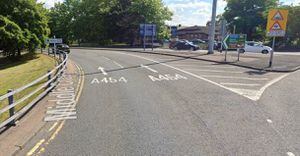
 The road leading up to the Snow Hill junction doesn't show a sign for the railway station. Photo: Google Street Map
I will agree with the reader that there isn't a noticeable sign as you head up to the four lane junction at Grove Street, so you do have to make a judgement call and go into a lane.
 As you turn onto the city centre roundabout, you will see the British Rail logo on a sign. Photo: Google Street Map
However, when you get to the Wolverhampton ring road at the Snow Hill Junction, there are signs, albeit not huge signs, which show the British Rail logo for the railway.
If you turn left at the junction and head down towards the old BT building, with the Way Youth Zone on your right, you can follow the ring road and, as you pass Sainsburys on Raglan Street, the signs appear for the station.
 Another sign appears heading down the ring road. Photo: Google Street Map
 Another one is clear as you enter the Bilston Street Roundabout. Photo: Google Street Map
In my own drive, I turned right at the lights, then followed the ring road down to the lights at the Bilston Street roundabout, which overlook the metro bridge and have the Combined Courts to the left and Novotel to the right.
 Turning around the roundabout, another sign appears. Photo: Google Street Map
 There are two signs marking which way to go as you approach the A454. Photo: Google Street Map
You will see other signs which show the British Rail logo and arrows pointing in the direction traffic is required to follow. pointing both right and left and follow the A454 Willenhall Road.
 Follow the A454 down and there is another sign. Photo: Google Street Map
As you follow down that road, you'll see another sign which says to take a left onto Horseley Fields, then a right turn onto Corn Hill where, at this point, all signs point towards Wolverhampton railway station.
 There is a smaller sign showing on Horseley Fields. Photo: Google Street Map
Even if you follow the road around onto Gough Street, you'll follow around to the lights and see the station right in front of you.
 Once you make the turn, the station is clearly in view. Photo: Google Street Map
I will agree that signage on Grove Street is not clear as to which way to go, but I will also say that once you are on the city centre ring road, the station is clearly signposted, so should be ok to find.
However, as someone who has tried to navigate his way round the centre of London in a car, I understand how hard it can be to find something when you are not familiar with the surroundings.